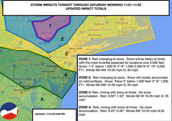
A coastal storm will continue to produce periods of rain along the coast while interior higher-elevation snowfall develops tonight. Unsettled conditions will continue towards the Thanksgiving weekend.
TONIGHT
The area of
low pressure will stall over the region, with periods of snow in the Poconos, Catskills, and Hudson Highlands and rain/snow showers elsewhere. Winds will be from the southwest at 10 to 20 mph. Temperatures will fall into the lower to mid-30s over the interior, mid to upper 30s in the suburbs, and upper 30s to lower 40s in urban areas for lows.
TOMORROW
A series of troughs will produce scattered rain and snow showers with accumulating snowfall in elevations above 1,000 feet in the Poconos and Catskills. Winds will be from the west-southwest at 10 to 20 mph with gusts up to 30 mph. Temperatures will rise into the mid to upper 30s over the interior and lower to mid-40s along the coast for highs.
TOMORROW
NIGHT
A series of troughs will produce variable clouds and scattered showers. Winds will be from the west at 10 to 20 mph. Temperatures will fall into the lower to mid-20s over the interior, upper 20s to lower 30s in the suburbs, and mid to upper 30s in urban areas for lows.
SATURDAY
A series of troughs will produce variable clouds and scattered showers. Winds will be from the west at 10 to 20 mph. Temperatures will rise into the lower to mid-40s over the interior and upper 40s to lower 50s along the coast for highs.
SUNDAY
A series of troughs will produce scattered
clouds and isolated showers. Winds will be from the northwest at 10 to 20 mph. Temperatures will range from the lower to mid-30s over the interior, upper 30s to lower 40s in the suburbs, and lower to mid-40s in urban areas for lows and lower to mid-40s over the interior, upper 40s to lower 50s in the New York City metropolitan area, and lower to mid-50s in the Philadelphia metropolitan area for highs.
MONDAY
High pressure will produce scattered clouds. Temperatures will range from the mid to upper 30s for lows and lower to mid-50s over the interior, mid to upper 50s in the New York City metropolitan area, and upper 50s to lower 60s in the Philadelphia metropolitan area for highs.
TUESDAY
An area of low pressure and a cold front will produce scattered showers. Temperatures will range from the mid to upper 30s over the interior and lower to mid-40s along the coast for lows and lower to mid-40s over the interior and upper 40s to lower 50s along the coast for highs.
WEDNESDAY (THANKSGIVING EVE)
High pressure will produce scattered clouds. Temperatures will range from the upper 20s to lower 30s over the interior, lower to mid-30s in the suburbs, and mid to upper 30s in urban areas for lows and upper 30s to lower 40s over the interior and lower to mid-40s along the coast for highs.
THANKSGIVING
An area of low pressure will approach the region with rain and snow. Temperatures will range from the upper 20s to lower 30s for lows and lower to mid-30s over the interior and upper 30s to lower 40s along the coast for highs.