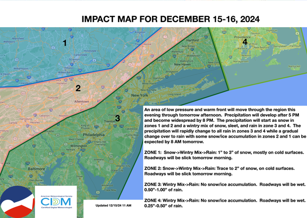
An area of low pressure will approach, with snow, sleet, and rain expected by this evening through tomorrow morning. An active weather pattern this week will give way to chilly conditions by next weekend.
TODAY
High pressure
will exit with increasing clouds. Precipitation will develop towards evening with a mix of snow, sleet, and rain. Winds will veer from the northeast to the east at 5 to 10 mph. Temperatures will rise into the lower to mid-30s over the interior and upper 30s to lower 40s along the coast for highs.
TONIGHT
An area of low
pressure will produce light snow over the Poconos, Catskills, Hudson Highlands, and Hudson River Valley, while rain will develop elsewhere. A dusting to two inches of snow can be expected before changing over to rain towards morning. Winds will be from the east at 5 to 15 mph. Temperatures will hold in the lower to mid-30s over the interior and upper 30s to lower 40s along the coast for lows towards midnight before rising through the morning
hours.
TOMORROW
An area of low pressure will pass through the region with a wintry mix changing to rain over the interior and rain along the coast. Winds will be from the east at 5 to 15 mph. Temperatures will rise into the mid to upper 40s over the interior and lower to mid-50s along the coast for
highs.
TOMORROW NIGHT
Showers will pass through the region. Winds will veer from the east to the southeast at 5 to 15 mph. Temperatures will fall into the lower to mid-40s over the interior and upper 40s to lower 50s along the coast for lows.
TUESDAY
An area of low pressure will produce periods of showers in the morning, followed by scattered clouds. Winds will veer from the southeast to the southwest at 5 to 15 mph. Temperatures will rise into the mid-40s to lower 50s over the interior and mid to upper 50s along the coast for highs.
WEDNESDAY
An area of low pressure will pass through the region with periods of rain by the afternoon. Winds will be from the southeast at 1 to 5 mph. Temperatures will range from the mid to upper 20s over the interior and lower to mid-30s along the coast for lows and lower to mid-40s over the interior, upper 40s to lower 50s in the Delaware River Valley, and
lower to mid-50s along the coast for highs.
THURSDAY
A series of troughs will pass through the region with scattered clouds and flurries. Temperatures will range from the upper 20s to lower 30s over the interior and mid to upper 30s along the coast for lows and lower to mid-30s over the interior and upper 30s to lower 40s along the
coast for highs.
FRIDAY
A series of troughs will pass through the region with scattered clouds and flurries. Temperatures will range from the upper 10s to lower 20s over the interior and lower to mid-20s along the coast for lows and mid to upper 30s over the interior and lower to mid-40s along the coast for
highs.
SATURDAY
A series of troughs will pass through the region with scattered clouds and flurries. Temperatures will range from the upper 10s to lower 20s over the interior, mid to upper 20s in the suburbs, and upper 20s to lower 30s in urban areas for lows and mid to upper 20s over the interior and lower to mid-30s along the coast
for highs.
SUNDAY
A series of troughs will pass through the region with scattered clouds and flurries. Temperatures will range from the lower to mid-10s over the interior and upper 10s to lower 20s along the coast for lows and lower to mid-10s over the interior, upper 10s to lower 20 in the New York City metropolitan area, and lower to
mid-20s in the Philadelphia metropolitan area for highs.