An area of low pressure developing off the coast will bring periods of light snow to much of the region, with some minor snow accumulations. Brutally cold conditions will take hold this weekend.
TODAY
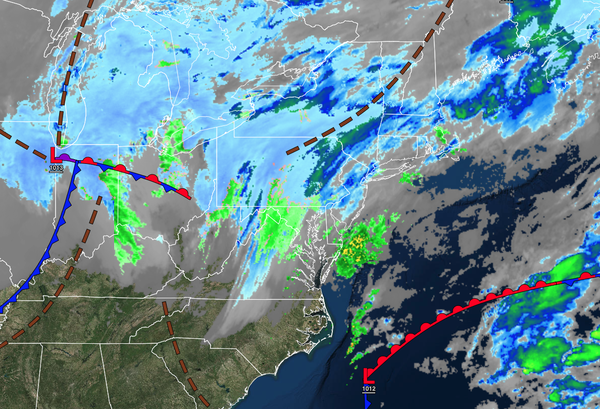
An arctic cold front
to the west and an area of low pressure over the coastal waters will produce increasing clouds and rain/snow showers by this afternoon. Winds will back from the northeast to the north at around 5 to 10 mph. Temperatures will rise into the lower to mid-30s over the interior and upper 30s to lower 40s along the coast for highs.
TONIGHT
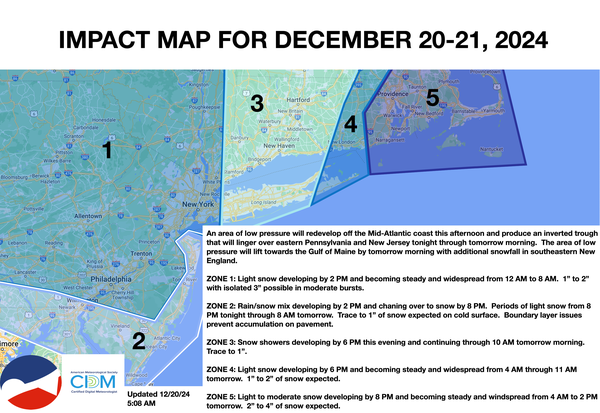
As an inverted trough develops over the region, periods of light snow can be expected in eastern Pennsylvania, New Jersey, and the New York City metropolitan area, while snow showers will linger over the Hudson River Valley, Connecticut, and Long Island. See the impact map below for accumulation details. Winds will veer from the north to the northwest at 5 to 15 mph. Temperatures will fall into the upper 10s to lower 20s over the interior,
mid to upper 20s in the suburbs, and upper 20s to lower 30s in urban areas for lows.
TOMORROW
A series of troughs will pass through the region with scattered clouds and flurries. Winds will be from the northwest at 10 to 20 mph. Temperatures will rise into the lower to mid-20s over the interior and upper 20s to lower 30s along
the coast for highs. Wind chills will be in the single digits to teens.
TOMORROW NIGHT
A series of troughs will pass through the region with scattered clouds and flurries. Winds will be from the northwest at 5 to 15 mph. Temperatures will fall into the single digits over the interior and lower to mid-10s along the coast for
lows.
SUNDAY
A series of troughs will pass through the region with scattered clouds and flurries. Winds will be from the northwest at 5 to 15 mph. Temperatures will rise into the lower to mid-10s over the interior and upper 10s to lower 20s along the coast for highs.
MONDAY
A series of troughs will pass through the region with scattered clouds and flurries. Temperatures will range from the single digits over the interior and lower to mid-10s along the coast for lows and lower to mid-20s over the interior and mid to upper 20s along the coast for highs.
TUESDAY
CHRISTMAS EVE
An area of low pressure will approach the region with increasing clouds, followed by rain/snow showers in the evening. Temperatures will range from the mid to upper 10s over the interior and upper 10s to lower 20s along the coast for lows and upper 20s to lower 30s over the interior and mid to upper 30s along the coast for highs.
WEDNESDAY CHRISTMAS
Scattered clouds are expected. Temperatures will range from the upper 20s to lower 30s for lows and mid to upper 30s for highs.
THURSDAY
Scattered clouds are expected. Temperatures will
range from the lower to mid-30s over the interior and mid to upper 30s along the coast for lows, and upper 30s to lower 40s for highs.
FRIDAY
Scattered clouds are expected. Temperatures will range from the mid to upper 10s over the interior, lower to mid-20s in the suburbs, and upper 20s to lower 30s in urban areas for lows and lower
to mid-40s for highs.