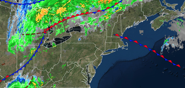
A cold front will support the potential for strong and severe thunderstorms this afternoon and evening. A tropical, hot, and humid weather pattern will develop this weekend and continue through next week.
TODAY
A cold front
will move through the region with scattered showers and thunderstorms. A few isolated severe thunderstorms will be possible with heavy downpours, frequent lightning, hail, and wind gusts over 55 mph. Winds will be from the southwest at 5 to 15 mph. High temperatures will range from the upper 70s to the lower 80s on Long Island, lower to mid-80s along the coast, upper 80s to lower 90s on the I-95 corridor, and lower to mid-80s over the interior.
TONIGHT
High pressure will produce scattered clouds. Winds will be from the west at 5 to 10 mph. Low temperatures will range from the mid to upper 50s over the interior and lower to mid-60s along the coast.
TOMORROW
A trough will pass through the region with scattered clouds and isolated thunderstorms. Winds will be from the west at 5 to 10 mph. High temperatures will range from the mid to upper 70s over the interior and lower to mid-80s along the coast.
TOMORROW NIGHT
High pressure will produce
scattered clouds. Winds will be from the southwest at 5 to 10 mph. Low temperatures will range from the lower to mid-60s.
SATURDAY
High pressure will produce scattered clouds. An isolated thunderstorm will be a threat. Winds will be from the southwest at 5 to 10 mph. High temperatures will range from the lower
to mid-80s over the interior, lower to mid-80s along the coast, and upper 80s to lower 90s on the I-95 corridor.
SUNDAY
High pressure will produce scattered clouds. An isolated thunderstorm will be a threat along the coast. Winds will be from the southwest at 5 to 15 mph. Low temperatures will range from the upper 60s to
lower 70s over the interior, upper 60s to lower 70s in the suburbs, and lower to mid-70s in urban areas. High temperatures will range from the upper 80s to lower 90s over the interior, upper 80s to lower 90s along the coast, and mid to upper 90s on the I-95 corridor. A heat index in the upper 90s to lower 100s is expected.
MONDAY
High pressure will produce scattered clouds. An isolated thunderstorm will be a threat along the coast. Low temperatures will range from the lower to mid-70s over the interior, mid to upper 70s in the suburbs, and upper 70s to lower 80s in urban areas. High temperatures will range from the upper 80s to lower 90s over the interior, upper 80s to lower 90s along the coast, and mid to upper 90s on the I-95 corridor. A heat index in the
100s is expected.
TUESDAY
High pressure will produce scattered clouds. An isolated thunderstorm will be a threat along the coast. Low temperatures will range from the lower to mid-70s over the interior, mid to upper 70s in the suburbs, and upper 70s to lower 80s in urban areas. High temperatures will range from the upper
80s to lower 90s over the interior, upper 80s to lower 90s along the coast, and mid to upper 90s on the I-95 corridor. A heat index in the 100s is expected.
WEDNESDAY
High pressure will produce scattered clouds. An isolated thunderstorm will be a threat along the coast. Low temperatures will range from the lower to mid-70s
over the interior, mid to upper 70s in the suburbs, and upper 70s to lower 80s in urban areas. High temperatures will range from the upper 80s to lower 90s over the interior, upper 80s to lower 90s along the coast, and mid to upper 90s on the I-95 corridor. A heat index in the 100s is expected.
THURSDAY
A cold front will move
through the region with showers and thunderstorms in the late afternoon and evening. Low temperatures will range from the upper 60s to lower 70s over the interior, upper 60s to lower 70s in the suburbs, and lower to mid-70s in urban areas. High temperatures will range from the upper 80s to the lower 90s over the interior, lower to mid-90s along the coast, and mid to upper 90s on the I-95 corridor. A heat index in the 100s is expected.