After stifling heat, the week will end cool and cloudy with a few pesky showers. A turn to seasonable conditions is expected this weekend.
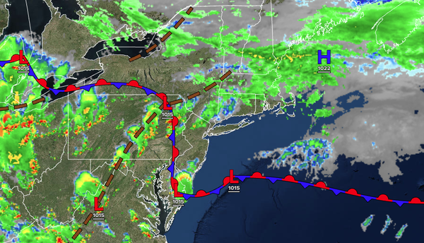
TODAY
A stationary front will linger around the region with cloudy skies, drizzle,
and scattered showers. Winds will veer to the east at 5 to 10 mph. High temperatures will range from the lower to mid-70s over the interior and along the coast, and mid to upper 70s in the Delaware River Valley.
TONIGHT
A warm front will approach the region with variable clouds and isolated showers. Winds will be from the
southeast at 5 to 10 mph. Low temperatures will range from the mid to upper 60s.
TOMORROW
A warm front will produce scattered clouds and widely scattered showers. Winds will veer to the southwest at 5 to 10 mph. High temperatures will range from the upper 70s to the lower 80s along the coast, mid to upper 80s on the I-95
corridor, and lower to mid-80s over the interior.
TOMORROW NIGHT
A cold front will approach the region with scattered showers and thunderstorms. Winds will be from the southwest at 5 to 10 mph. Low temperatures will range from the mid to upper 60s over the interior and lower to mid-70s along the
coast.
SUNDAY
A cold front will clear the coast in the morning with scattered showers. Scattered clouds are expected in the afternoon. Winds will veer to the west at 5 to 10 mph. High temperatures will range from the lower to mid-80s over the interior, lower to mid-80s along the coast, and mid to upper 80s on the I-95
corridor.
MONDAY
A trough will produce scattered clouds. Isolated showers will be a threat by the evening. Winds will be from the southwest at 5 to 10 mph. Low temperatures will range from the mid to upper 60s. High temperatures will range from the mid to upper 80s along the coast, mid to upper 80s over the interior,
and upper 80s to lower 90s on the I-95 corridor.
TUESDAY
A cold front will move through the region with scattered showers and thunderstorms. Low temperatures will range from the upper 60s to the lower 70s over the interior and lower to mid-70s along the coast. High temperatures will range from the upper 70s to the lower 80s over
the interior and mid to upper 80s along the coast.
WEDNESDAY
High pressure will produce scattered clouds. Low temperatures will range from the mid to upper 60s over the interior and lower to mid-70s along the coast. High temperatures will range from the lower to mid-80s.
THURSDAY
High pressure will produce scattered clouds. Low temperatures will range from the lower to mid-60s over the interior and mid to upper 60s along the coast. High temperatures will range from the lower to mid-80s over the interior and mid to upper 80s along the coast.
FRIDAY
A trough will pass through the region with scattered clouds and isolated showers. Low temperatures will range from the mid to upper 60s over the interior and upper 60s to lower 70s along the coast. High temperatures will range from the upper 70s to the lower 80s over the interior and mid to upper 80s along the coast.