A cold front will drive through the region this evening with scattered thunderstorms. Excellent weather returns for the Independence Day Weekend! Tropical mischief will have to be watched for early next week.
TODAY
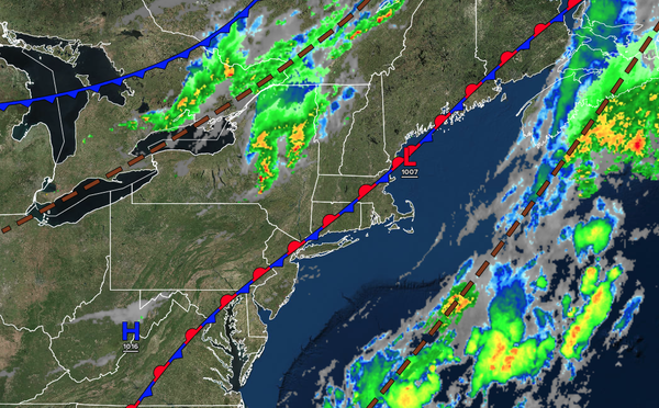
A stationary front will linger over the region, accompanied by scattered clouds, this morning. A cold front is expected to approach this afternoon and evening, bringing scattered showers and thunderstorms. The thunderstorms will be capable of heavy downpours, frequent lightning, hail, and wind gusts over 40 mph. Winds will be from the west at 5 to 10 mph. High temperatures will range from the upper 70s to the lower 80s over the
interior, the mid to upper 80s on the I-95 corridor, and the lower to mid-80s along the coast.
TONIGHT
A cold front will move through the region with scattered thunderstorms through this evening. Skies will clear after midnight. Winds will veer to the northwest at 5 to 10 mph. Low temperatures will range from the mid to
upper 50s over the interior, upper 50s to lower 60s in the suburbs, and lower to mid-60s in urban areas.
TOMORROW: INDEPENDENCE DAY
FRIDAY
High pressure will produce scattered clouds. Winds will be from the northwest at 5 to 10 mph. High temperatures will range from the mid to upper 70s over the interior and lower to mid-80s along the coast, with low humidity!
TOMORROW
NIGHT
High pressure will produce scattered clouds. Winds will be from the northwest at 1 to 5 mph. Low temperatures will range from the mid to upper 50s over the interior, upper 50s to the lower 60s in the suburbs, and lower to mid-60s in the urban areas.
SATURDAY
High pressure will produce scattered clouds. Winds will be from the southwest at 1 to 5 mph. High temperatures will range from the upper 70s to the lower 80s along the coast and the lower to mid-80s away from the coast with low humidity!
SUNDAY
High pressure will produce scattered
clouds. Winds will be from the southwest at 5 to 10 mph. Low temperatures will range from the mid to upper 60s. High temperatures will range from the lower to mid-80s along the coast, from the upper 80s to the lower 90s on the I-95 corridor, and from the mid- to upper-80s over the interior.
MONDAY
An area of low pressure
over the coastal waters will produce scattered showers capable of heavy downpours along the coast. Scattered clouds are expected north and northwest of the I-95 corridor. Low temperatures will range from the upper 60s to the lower 70s over the interior and the lower to mid-70s along the coast. High temperatures will range from the lower to mid-80s along the coast, upper 80s to lower 90s on the I-95 corridor, and mid to upper 80s over the
interior.
TUESDAY
A cold front will move through the region with scattered showers and thunderstorms. Low temperatures will range from the mid- to upper 60s over the interior to the lower to mid-70s along the coast. High temperatures will range from the lower to mid-80s over the interior, from the upper 80s to mid-90s along the
I-95 corridor, and from the upper 80s to the lower 90s along the coast.
WEDNESDAY
A trough will produce scattered clouds and isolated showers. Low temperatures will range from the upper 50s to the lower 60s over the interior, from the mid to upper 60s in the suburbs, and from the upper 60s to the lower 70s in urban areas. High
temperatures will range from the lower to mid-80s over the interior, upper 80s to mid-90s on the I-95 corridor, and upper 80s to lower 90s along the coast.
THURSDAY
A trough will produce scattered clouds and isolated showers. Low temperatures will range from the lower to mid-60s over the interior and upper 60s to lower 70s along the
coast. High temperatures will range from the mid to upper 80s on Long Island, upper 80s to lower 90s along the coast, lower to mid-90s on the I-95 corridor, and upper 80s to lower 90s over the interior.