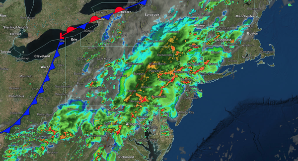
Tropical downpours will slowly invade the region through the evening with the threat of localized flash flooding and damaging winds via downbursts. Poor driving conditions are expected through the evening rush hour.
TONIGHT
A cold front will slowly approach the region with waves of showers and thunderstorms. The thunderstorms will be capable of intense downpours, frequent lightning, hail, and wind gusts over 50 mph. Flash flooding will be a threat on the I-95 corridor. Winds will be light and variable outside of the thunderstorms. Low temperatures will range from the mid to upper 60s over the interior, upper 60s to lower 70s in the suburbs, and lower to
mid-70s in urban areas.
TOMORROW
A cold front will sink through the region with scattered showers and thunderstorms. Winds will be light and variable outside of the thunderstorms. High temperatures will range from the lower to mid-80s.
TOMORROW
NIGHT
A stationary front will produce scattered clouds and isolated thunderstorms. Winds will be from the south at 1 to 5 mph. Low temperatures will range from the mid to upper 60s over the interior, upper 60s to lower 70s in the suburbs, and lower to mid-70s in urban areas.
WEDNESDAY
A trough of low pressure will produce scattered clouds and isolated thunderstorms. Winds will be from the south at 1 to 5 mph. High temperatures will range from the lower to mid-80s.
THURSDAY
A cold front will produce scattered showers and thunderstorms. Winds will be from the southwest
at 5 to 10 mph. Low temperatures will range from the lower to mid-70s. High temperatures will range from the lower to mid-80s over the interior, upper 80s to lower 90s on the I-95 corridor, and lower to mid-80s along the coast.
FRIDAY
A cold front will move through the region with showers and thunderstorms. Low temperatures
will range from the lower to mid-70s over the interior, mid to upper 70s in the suburbs, and upper 70s to lower 80s in urban areas. High temperatures will range from the lower to mid-80s over the interior, upper 80s to lower 90s on the I-95 corridor, and mid to upper 80s along the coast.
SATURDAY
A trough will produce scattered clouds
and isolated thunderstorms. Low temperatures will range from the mid to upper 60s over the interior, upper 60s to lower 70s in the suburbs, and lower to mid-70s in urban areas. High temperatures will range from the lower to mid-80s over the interior, upper 80s to lower 90s on the I-95 corridor, and mid to upper 80s along the coast.
SUNDAY
A cold front will produce scattered showers and thunderstorms. Low temperatures will range from the mid to upper 60s over the interior, upper 60s to lower 70s in the suburbs, and lower to mid-70s in urban areas. High temperatures will range from the lower to mid-80s over the interior, mid to upper 80s on the I-95 corridor, and lower to mid-80s along the coast.
MONDAY
The cold front will exit with lingering thunderstorms in the morning, followed by clearing skies. Low temperatures will range from the mid to upper 60s over the interior, upper 60s to lower 70s in the suburbs, and lower to mid-70s in urban areas. High temperatures will range from the mid to upper 70s over the interior and lower to mid-80s along and
southeast of I-95.