Another round of showers and thunderstorms will return this evening through tomorrow. More tranquil conditions are expected by the end of the week!
TODAY
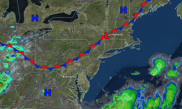
A wave of low pressure along the stationary front will produce
scattered showers and thunderstorms in the afternoon. Winds will be from the southwest at 1 to 5 mph. High temperatures will range from the mid to upper 80s.
TONIGHT
A wave of low pressure along the stationary front will produce scattered showers and thunderstorms. Winds will be from the southwest at 5 to 10 mph. Low
temperatures will range from the lower to mid-70s.
TOMORROW
The stationary front will linger over the region, accompanied by scattered clouds and isolated thunderstorms. Winds will be from the southwest at 5 to 10 mph. High temperatures will range from the lower to mid-80s over the interior, upper 80s to lower 90s on the I-95
corridor, and lower to mid-80s along the coast.
TOMORROW NIGHT
A cold front will move through the region with scattered showers and thunderstorms. Winds will veer from the southwest to the northwest at 5 to 10 mph. Low temperatures will range from the mid to upper 60s over the interior, lower to mid-70s in the suburbs, and mid to
upper 70s in urban areas.
FRIDAY
The cold front will clear the region with lingering showers in the morning. Scattered clouds are expected in the afternoon. Winds will be from the northwest at 5 to 10 mph. High temperatures will range from the mid-70s to the lower 80s over the interior, from the mid to upper 80s along the
I-95 corridor, and from the lower to mid-80s along the coast.
SATURDAY
High pressure will produce scattered clouds. Winds will veer to the east at 1 to 5 mph. Low temperatures will range from the mid-50s to the upper 50s over the interior, from the lower to mid-60s in the suburbs, and from the mid- to upper 60s in urban
areas. High temperatures will range from the lower to mid-80s over the interior, upper 80s to lower 90s on the I-95 corridor, and lower to mid-80s along the coast.
SUNDAY
A cold front will produce scattered showers and thunderstorms. Low temperatures will range from the mid- to upper 60s over the interior to the lower to mid-70s along
the coast. High temperatures will range from the lower to mid-80s over the interior, upper 80s to lower 90s along the I-95 corridor, and mid-to-upper 80s along the coast.
MONDAY
The cold front will exit with lingering showers in the morning, followed by clearing skies. Low temperatures will range from the upper 50s to the lower
60s over the interior, from the lower to mid-60s in the suburbs, and from the mid to upper 60s in urban areas. High temperatures will range from the mid to upper 70s over the interior, lower to mid-80s on the I-95 corridor, and upper 70s to lower 80s along the coast.
TUESDAY
High pressure will produce scattered clouds. Low
temperatures will range from the mid-50s to the upper 50s over the interior and from the lower to mid-60s along the coast. High temperatures will range from the mid to upper 70s over the interior, lower to mid-80s on the I-95 corridor, upper 70s to lower 80s along the coast, and mid to upper 70s on Long Island.
WEDNESDAY
High pressure
will produce scattered clouds. Low temperatures will range from the upper 50s to the lower 60s over the interior and the lower to mid-60s along the coast. High temperatures will range from the upper 70s to the lower 80s along the coast, mid-to-upper 80s on the I-95 corridor, and lower to mid-80s over the interior.