Waves of showers and thunderstorms will develop throughout this afternoon, followed by widespread rainfall tonight into tomorrow morning, with flash flooding a high threat. Excellent weather returns for the weekend!
TODAY
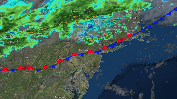
A cold front will stall over the region with scattered showers and thunderstorms in the morning, becoming widespread in the afternoon. The thunderstorms will be capable of heavy downpours, frequent lightning, and wind gusts over 40 mph. Flooding will be a threat. Winds will be from the northeast at 1 to 5 mph. High temperatures will range from the mid-70s to the mid-80s over the interior, from the mid to upper 80s in the New York City
metropolitan area, and from the upper 80s to the lower 90s in the Philadelphia metropolitan area.
TONIGHT
An area of low pressure will develop along the stalled front with widespread showers and thunderstorms. The thunderstorms will be capable of heavy downpours, frequent lightning, and wind gusts over 40 mph. Flooding is a
threat. Winds will be from the northeast at 5 to 10 mph. Low temperatures will range from the upper 50s to the lower 60s over the interior, lower to mid-60s in the suburbs, and mid to upper 60s in urban areas.
TOMORROW
An area of low pressure along the cold front will produce periods of heavy rainfall in the morning.
Flooding will be a threat. Skies will clear with a few lingering showers in the afternoon. Winds will be from the northeast at 5 to 15 mph. High temperatures will range from the upper 60s to lower 70s over the interior and mid to upper 70s along the coast.
TOMORROW NIGHT
High pressure will build into the region with
clearing skies. Winds will be from the northeast at 5 to 15 mph. Low temperatures will range from the lower 50s to the mid-50s over the interior, from the upper 50s to the lower 60s in the suburbs, and from the lower to mid-60s in urban areas.
SATURDAY
High pressure will produce scattered clouds. Winds will be from the northeast
at 5 to 15 mph. High temperatures will range from the lower to mid-70s over the interior, upper 70s to lower 80s on the I-95 corridor, and mid to upper 70s along the coast.
SUNDAY
High pressure will produce scattered clouds. Low temperatures will range from the mid-50s to the upper 50s over the interior and from the lower to
mid-60s along the coast. High temperatures will range from the mid to upper 70s over the interior and upper 70s to the lower 80s along the coast.
MONDAY
High pressure will produce scattered clouds. Low temperatures will range from the mid-50s to the upper 50s over the interior and from the lower to mid-60s along the coast. High
temperatures will range from the lower to mid-80s over the interior, mid to upper 80s on the I-95 corridor, and lower to mid-80s along the coast.
TUESDAY
High pressure will produce scattered clouds. Low temperatures will range from the lower to mid-60s over the interior and mid to upper 60s along the coast. High temperatures will
range from the lower to mid-80s over the interior, mid to upper 80s on the I-95 corridor, lower to mid-80s along the coast, and upper 70s to lower 80s on Long Island.
WEDNESDAY
A cold front will produce scattered showers and isolated thunderstorms. Low temperatures will range from the lower to mid-60s over the interior, mid to upper
60s in the suburbs, and upper 60s to lower 70s in urban areas. High temperatures will range from the mid to upper 70s.
THURSDAY
An area of low pressure will produce periods of showers. Low temperatures will range from the lower to mid-60s over the interior and mid to upper 60s along the coast. High temperatures will range
from the lower to mid-70s.