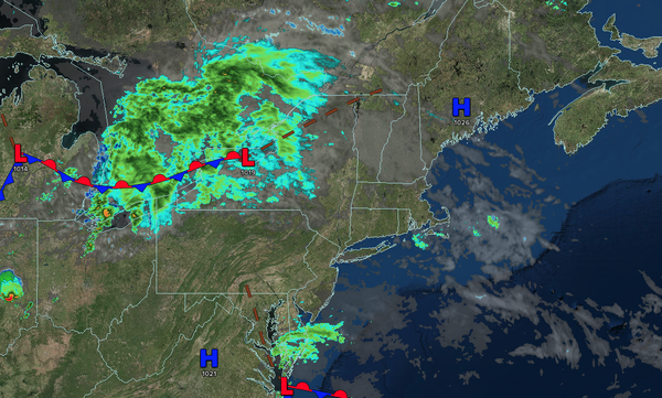
An onshore flow will support cool conditions with variable clouds and isolated showers through tomorrow morning. A wave of low pressure will produce periods of showers capable of tropical downpours tomorrow afternoon. Influences from Hurricane Erin will produce enhanced wave heights, dangerous rip currents, and minor coastal flooding through
Friday.
TONIGHT
A stationary front will produce variable clouds and isolated showers. Winds will be from the east at 5 to 10 mph. Low temperatures will range from the lower to mid-60s.
TOMORROW
A wave of low pressure will approach with increasing clouds and periods of showers in the afternoon. The showers will be capable of heavy downpours. Winds will be from the east at 5 to 10 mph. High temperatures will range from the upper 60s to lower 70s over the interior, mid to upper 70s on the I-95 corridor, and mid-70s along the coast.
TOMORROW
NIGHT
An area of low pressure will produce periods of showers capable of heavy downpours. Winds will be from the northeast at 5 to 10 mph. Low temperatures will range from the lower to mid-60s over the interior and mid to upper 60s along the coast.
THURSDAY
The cold front and low-pressure system will exit off the coast with periods of showers in the morning, followed by clearing skies. Winds will be from the northeast at 5 to 15 mph with gusts over 20 mph along the coast. High temperatures will range from the lower to mid-70s.
FRIDAY
High
pressure will build into the region with clear skies. Winds will be from the north at 5 to 15 mph with gusts over 20 mph along the coast. Low temperatures will range from the mid to upper 50s over the interior and upper 50s to lower 60s along the coast. High temperatures will range from the mid to upper 70s.
SATURDAY
High
pressure will produce scattered clouds. Low temperatures will range from the mid to upper 50s over the interior and upper 50s to lower 60s along the coast. High temperatures will range from the mid to upper 70s on Long Island and upper 70s to lower 80s elsewhere.
SUNDAY
A trough will produce scattered clouds and isolated
thunderstorms. Low temperatures will range from the mid to upper 60s. High temperatures will range from the mid to upper 70s over the interior, upper 70s to lower 80s on the I-95 corridor, and mid to upper 70s along the coast.
MONDAY
A cold front will produce scattered showers and thunderstorms. Low temperatures will range
from the lower to mid-60s over the interior, mid to upper 60s in the suburbs, and upper 60s to lower 70s in urban areas. High temperatures will range from the mid to upper 70s.
TUESDAY
A trough will produce scattered clouds and isolated showers. Low temperatures will range from the mid to upper 50s over the interior and lower to
mid-60s along the coast. High temperatures will range from the upper 60s to lower 70s over the interior and lower to mid-70s along the coast.