Scattered showers and thunderstorms will be a threat through tomorrow, but not everyone will have rainfall. Another rainstorm will be brewing by the end of next week.
TODAY
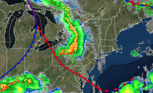
A warm front will approach the region with
variable clouds along with scattered showers and thunderstorms. The thunderstorms will be capable of heavy downpours, frequent lightning, hail, wind gusts over 40 mph, and isolated tornadoes. Winds will be from the southeast at 5 to 15 mph. High temperatures will range from the upper 60s to the lower 70s on Long Island, mid to upper 70s along the coast, upper 70s to the lower 80s in the Delaware River Valley, and mid to upper 70s over the
interior.
TONIGHT
A warm front will lift through the region with variable clouds along the scattered showers and thunderstorms. The thunderstorms will be capable of heavy downpours, frequent lightning, hail, wind gusts over 40 mph, and isolated tornadoes. Winds will veer from the southeast to the southwest at 5 to 15 mph.
Low temperatures will range from the upper 50s to the lower 60s over the interior and suburbs and lower to mid-60s in urban areas.
TOMORROW
A cold front will produce scattered showers and thunderstorms. The thunderstorms will be capable of heavy downpours, frequent lightning, hail, wind gusts over 40 mph, and isolated tornadoes.
Winds will be from the southwest at 5 to 15 mph. High temperatures will range from the mid to upper 70s over the interior, lower to mid-80s in the Delaware River Valley, and mid to upper 70s along the coast.
TOMORROW NIGHT
A series of troughs will pass through the region with scattered clouds and isolated showers. Winds will veer
from the southwest to the west at 5 to 15 mph. Low temperatures will range from the lower to mid-50s over the interior and upper 50s to the lower 60s along the coast.
SUNDAY
A trough will produce scattered clouds and isolated showers. Winds will be from the west at 10 to 20 mph with gusts up to 35 mph. High temperatures
will range from the mid to upper 60s over the interior and lower to mid-70s along the coast.
MONDAY
High pressure will build into the region with clearing skies. Winds will be from the northwest at 5 to 15 mph. Low temperatures will range from the upper 40s to the lower 50s over the interior and mid to upper 50s along the
coast. High temperatures will range from the mid to upper 60s over the interior and lower to mid-70s along the coast.
TUESDAY
High pressure will produce scattered clouds. Low temperatures will range from the lower to mid-40s over the interior and upper 40s to lower 50s along the coast. High temperatures will range from the
mid-50s to the lower 60s over the interior, mid to upper 60s in the Delaware River Valley, and lower to mid-60s along the coast.
WEDNESDAY
An area of low pressure will approach the region with increasing clouds and periods of rain developing in the afternoon. Low temperatures will range from the mid to upper 40s over the interior and
upper 40s to lower 50s along the coast. High temperatures will range from the lower to mid-50s over the interior and mid to upper 50s along the coast.
THURSDAY
An area of low pressure will produce periods of rain, heavy at times. Low temperatures will range from the mid to upper 40s over the interior and lower to mid-50s along
the coast. High temperatures will range from the lower to mid-60s over the interior and mid to upper 60s along the coast.
FRIDAY
An area of low pressure will exit the region with variable clouds and scattered showers. Low temperatures will range from the mid to upper 40s over the interior and upper 40s to lower 50s along the
coast. High temperatures will range from the mid to upper 50s over the interior and upper 50s to lower 60s along the coast.