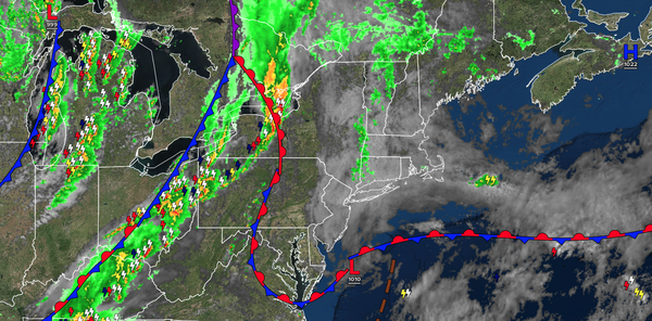
A warm front will slowly lift through the region with periods of showers and isolated thunderstorms tomorrow morning, followed by a cold front with additional thunderstorms tomorrow afternoon and evening.
TONIGHT
A warm front
will lift through the region with overcast skies, drizzle, and isolated showers. Winds will veer from the east to the southwest at 5 to 10 mph. Low temperatures will fall into the lower to mid-60s.
TOMORROW
A cold front will move through the region with scattered showers and thunderstorms. The thunderstorms will be capable
of heavy downpours, vivid lightning, and wind gusts over 40 mph. Winds will be from the southwest at 5 to 10 mph. High temperatures will range from the mid to upper 70s along the coast, mid to upper 70s over the interior, and lower to mid-80s on the I-95 corridor.
TOMORROW NIGHT
High pressure will build into the region with
clearing skies. Winds will be from the west at 5 to 10 mph. Low temperatures will range from the mid to upper 50s over the interior and lower to mid-60s along the coast.
WEDNESDAY
High pressure will produce scattered clouds. Winds will be from the west at 5 to 10 mph. High temperatures will range from the mid to upper
70s over the interior, upper 70s to lower 80s along the coast, and lower to mid-80s on the I-95 corridor.
THURSDAY
High pressure will produce scattered clouds. Winds will be from the west at 5 to 10 mph. Low temperatures will range from the lower to mid-60s over the interior and mid to upper 60s along the coast. High
temperatures will range from the upper 70s to the lower 80s over the interior, the lower to mid-80s along the coast, and the mid to upper 80s on the I-95 corridor.
FRIDAY
A cold front will approach the region with scattered clouds and isolated showers. Low temperatures will range from the upper 50s to the lower 60s over the interior
and the lower to mid-60s along the coast. High temperatures will range from the mid-70s to the lower 80s over the interior, mid to upper 70s on Long Island, upper 70s to lower 80s along the coast, and mid-80s to lower 90s on the I-95 corridor.
SATURDAY
An area of low pressure will produce scattered showers. Low temperatures will
range from the lower to mid-60s. High temperatures will range from the lower to mid-70s over the interior, lower to mid-70s along the coast, and mid to upper 70s on the I-95 corridor.
SUNDAY
A stationary front will produce scattered clouds and isolated showers. Low temperatures will range from the upper 50s to the lower
60s. High temperatures will range from the upper 60s to the lower 70s over the interior and lower to mid-70s elsewhere.
MONDAY
An area of low pressure will produce periods of showers and thunderstorms. Low temperatures will range from the mid to upper 50s. High temperatures will range from the mid to upper 60s over the
interior, upper 60s to lower 70s along the coast, and lower to mid-70s on the I-95 corridor.