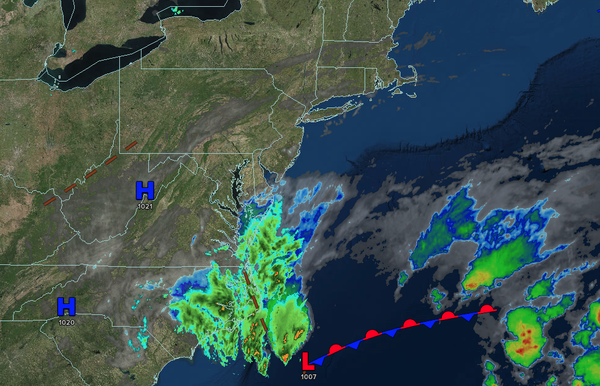
Excellent weather today will give way to increasing clouds and showers by mid-week as a coastal low-pressure system lingers off the coast.
TODAY
High pressure will produce scattered clouds. Winds will be from the
northeast at 1 to 5 mph. High temperatures will range from the upper 70s to the lower 80s along the coast and lower to mid-80s away from the coast.
TONIGHT
High pressure will exit the region with increasing clouds. Winds will be light and variable. Low temperatures will range from the mid to upper 50s over the interior and
lower to mid-60s along the coast.
TOMORROW
An area of low pressure will approach the region with increasing clouds and isolated showers. Winds will be from the east at 5 to 10 mph. High temperatures will range from the mid to upper 70s.
TOMORROW
NIGHT
An area of low pressure will produce increasing clouds with scattered showers. Winds will be from the east at 5 to 10 mph. Low temperatures will range from the mid to upper 50s over the interior and lower to mid-60s along the coast.
WEDNESDAY
An
area of low pressure will produce overcast skies and scattered showers. Winds will be from the east at 5 to 10 mph. High temperatures will range from the upper 60s to lower 70s along the coast and lower to mid-70s away from the coast.
THURSDAY
An area of low pressure will produce overcast skies and isolated showers. Winds
will back to the northwest at 1 to 5 mph. Low temperatures will range from the mid to upper 50s over the interior and lower to mid-60s along the coast. High temperatures will range from the upper 70s to lower 80s along the coast and lower to mid-80s away from the coast.
FRIDAY
A cold front will produce scattered clouds with
isolated to widely scattered showers. Low temperatures will range from the mid to upper 50s over the interior and lower to mid-60s along the coast. High temperatures will range from the upper 70s to lower 80s over the interior, mid to upper 80s on the I-95 corridor, and lower to mid-80s along the coast.
SATURDAY
A series of
troughs will produce scattered clouds and isolated showers. Low temperatures will range from the lower to mid-50s over the interior, upper 50s to lower 60s in the suburbs, and lower to mid-60s in urban areas. High temperatures will range from the mid to upper 70s over the interior, upper 70s to lower 80s along the I-95 corridor, and lower to mid-70s along the coast.
SUNDAY
A series of troughs will produce scattered clouds and isolated showers. Low temperatures will range from the mid to upper 50s over the interior, upper 50s to lower 60s in the suburbs, and lower to mid-60s in urban areas. High temperatures will range from the lower to mid-70s over the interior, mid to upper 70s on the I-95 corridor, and upper 60s to lower
70s along the coast.
MONDAY
A series of troughs will produce scattered clouds and isolated showers. Low temperatures will range from the lower to mid-60s. High temperatures will range from the upper 70s to lower 80s over the interior, lower to mid-80s on the I-95 corridor, upper 70s to lower 80s along the coast, and mid to upper
70s on Long Island.