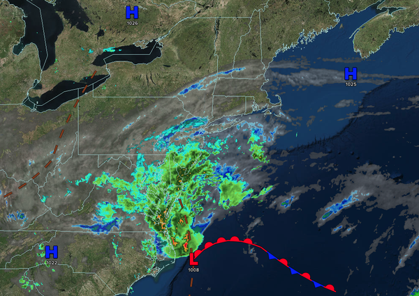
A coastal low-pressure system will produce increasing clouds and rainfall along the coast through tomorrow. An unsettled weather pattern will give way by the weekend!
TODAY
An area of low pressure over the coastal waters
will produce overcast skies with isolated showers northwest of the I-95 corridor, scattered showers along the I-95 corridor, and periods of rain over southern New Jersey. Winds will be from the east at 5 to 10 mph. High temperatures will range from the lower to mid-70s.
TONIGHT
An area of low pressure will produce overcast skies
with isolated showers to the northwest of the I-95 corridor and scattered showers capable of heavy downpours along and southeast of the I-95 corridor. Winds will be from the east at 5 to 10 mph. Low temperatures will range from the mid to upper 50s over the interior, upper 50s to lower 60s on the suburbs, and lower to mid-60s in urban areas.
TOMORROW
An area of low pressure will produce overcast skies with isolated showers to the northwest of the I-95 corridor and scattered showers capable of heavy downpours along and southeast of the I-95 corridor. Winds will be from the east at 5 to 10 mph. High temperatures will range from the mid to upper 60s over the interior and upper 60s to lower 70s along the coast.
TOMORROW
NIGHT
An area of low pressure will produce overcast skies with isolated showers to the northwest of the I-95 corridor and scattered showers capable of heavy downpours along and southeast of the I-95 corridor. Winds will be from the northeast at 5 to 10 mph. Low temperatures will range from the lower to mid-60s.
THURSDAY
An area of low pressure will exit the region with broken clouds and isolated showers. Winds will back to the northwest at 1 to 5 mph. High temperatures will range from the mid to upper 70s over the interior, upper 70s to lower 80s on the I-95 corridor, and mid to upper 70s along the coast.
FRIDAY
A cold front will produce scattered clouds with isolated to widely scattered showers. Winds will be from the northwest at 5 to 10 mph. Low temperatures will range from the mid to upper 50s over the interior and lower to mid-60s along the coast. High temperatures will range from the lower to mid-70s over the interior, upper 70s to mid-80s along the
I-95 corridor, and upper 70s to lower 80s along the coast.
SATURDAY
High pressure will produce scattered clouds. Low temperatures will range from the upper 40s to the lower 50s over the interior, mid to upper 50s in the suburbs, and upper 50s to lower 60s in urban areas. High temperatures will range from the lower to mid-70s over
the interior, mid to upper 70s on the I-95 corridor, and lower to mid-70s along the coast.
SUNDAY
A series of troughs will produce scattered clouds and isolated showers. Low temperatures will range from the mid to upper 50s over the interior and upper 50s to lower 60s along the coast. High temperatures will range from the upper
60s to lower 70s over the interior, mid to upper 70s on the I-95 corridor, and upper 60s to lower 70s along the coast.
MONDAY
A series of troughs will produce scattered clouds and isolated showers. Low temperatures will range from the lower to mid-60s. High temperatures will range from the mid to upper 70s over the interior,
upper 70s to lower 80s on the I-95 corridor, and mid to upper 70s along the coast.
TUESDAY
A cold front will produce scattered clouds and isolated showers. Low temperatures will range from the mid to upper 60s. High temperatures will range from the lower to mid-80s.