UPDATED 02/06/26 9:50 AM
Snow showers invade this evening as a new arctic cold front approaches. Light snow, strong winds, and dangerous wind chills will be in place throughout the Super Bowl weekend.
TODAY
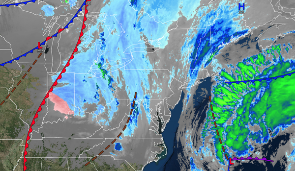
An area of low pressure will approach the region with increasing clouds. Snow showers are expected by the evening. Winds will be from the north at 1 to 5 mph. High temperatures will be in the mid to upper 20s.
TONIGHT
A new area of low pressure will develop over the coastal waters with scattered snow showers throughout the region. Light snow will develop over Long Island and Connecticut. Winds will be from the northwest at 5 to 15 mph. Low temperatures will range from the single digits below normal to the single digits above zero over the interior, the single digits to the lower 10s in the Delaware River Valley, and the lower to mid-10s along the
coast.
TOMORROW
An area of low pressure will exit the region with scattered snow showers. Winds will be from the northwest at 10 to 20 mph with gusts between 30 and 50 mph. High temperatures will range from the single digits to the lower 10s over the interior, from the lower to mid-10s in the Delaware River Valley, and from the
upper 10s to the lower 20s along the coast.
TOMORROW NIGHT
High pressure will build into the region with clearing skies. Winds will be from the northwest at 10 to 20 mph with gusts between 30 and 50 mph. Low temperatures will range from the single digits below zero to the single digits above zero.
SUNDAY
High pressure will produce scattered clouds. Winds will be from the northwest at 10 to 20 mph with gusts between 30 to 50 mph. High temperatures will range from the single digits to the lower 10s.
MONDAY
High pressure will produce scattered clouds. Low temperatures will range from the single digits below zero to the single digits above zero. High temperatures will range from the mid to upper 10s over the interior and upper 10s to lower 20s along the coast.
TUESDAY
High pressure will produce
scattered clouds. Low temperatures will range from the single digits below zero to the single digits above zero over the interior, single digits to lower 10s in the Delaware River Valley, and lower to mid-10s along the coast. High temperatures will range from the mid-20s to the lower 30s.
WEDNESDAY
An area of low pressure will pass
through the region with light wintry mix precipitation. Low temperatures will range from the lower to mid-10s. High temperatures will range from the upper 20s to the lower 30s.
THURSDAY
High pressure will produce scattered clouds. Low temperatures will range from the mid to upper 10s over the interior and upper 10s to lower
20s along the coast. High temperatures will range from the upper 20s to the lower 30s.
FRIDAY
High pressure will produce scattered clouds. Low temperatures will range from the mid to upper 10s over the interior and upper 10s to lower 20s along the coast. High temperatures will range from the upper 20s to the lower
30s.