UPDATED 02/20/26 3:25 PM
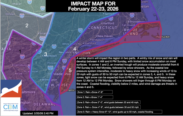
A major winter storm will impact the region on Sunday through Monday morning with a variety of impacts. Here are the details on this storm.
SUNDAY: 4 AM to 6
PM
As the low-pressure system develops to our south, scattered rain and snow showers will develop around the region. With temperatures in the 30s and 40s, snow accumulation will not be expected in this time period. Most of the region can expect temperatures to begin to fall towards freezing in the evening with minor snow accumulation on cold surfaces.
SUNDAY 6 PM to 12 AM
As the new coastal low-pressure system intensifies, an inverted trough will develop from the Delaware Coast to southeastern Pennsylvania, producing moderate snowfall in zone 1 and light snowfall in zone 2. With temperatures falling below freezing, snow accumulation will begin to increase on all surfaces. Meanwhile, light snowfall will begin
to develop in zones 3, 4, and 5.
MONDAY 12 AM to 12 PM
The coastal low-pressure system takes over and rapidly intensifies. As temperatures fall between the upper 20s and lower 30s throughout the region, all locations can expect snow accumulation. The snowfall will pick up intensity in zones 4 and 5 while zone 1 sees a decrease in
intensity. Zone 3 will be caught between the two heavy snowfall zones, which will keep the snowfall light to moderate. Meanwhile, the intensifying low-pressure system will support winds of 15 to 30 mph on the coast with gusts between 30 and 50 mph. Poor visibility and power outages will be a threat in zones 4 and 5. Coastal flooding will be a threat in zone 5.
MONDAY 12 PM to 6
PM
The low-pressure system departs with lingering snow showers. Temperatures will be in the lower to mid-30s with limited, if any, additional snowfall accumulation.
This snowfall will be a heavy, wet type of snow. Use caution with snow removal!