UPDATED 02/22/26 10:27 AM
Blizzard conditions will develop this evening and continue through tonight. A volatile weather pattern will continue through the end of February and continue into early March.
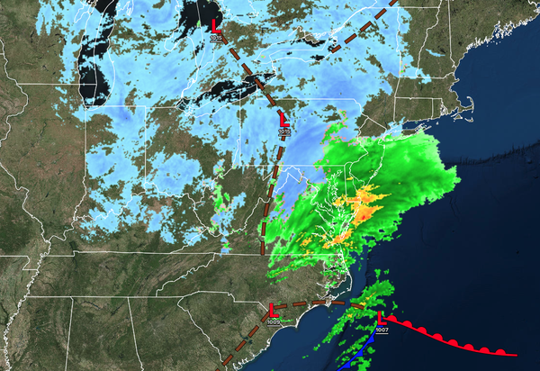
Please click here for details on the storm's timeline.
TODAY
An area of low pressure will develop well to the southeast of the region, with a trough lingering over the region, producing periods of light
snow. Most of the snow accumulation will be focused on cold surfaces. Moderate snowfall will develop towards the evening with steady snow accumulation around the region. Plowable snowfall is a threat along the New Jersey Coast, Long Island, and southeastern Pennsylvania. Winds will be from the northeast at 5 to 15 mph. High temperatures will range from the lower to mid-30s over the interior and mid to upper 30s along the coast.
TONIGHT
An area of low pressure will rapidly intensify over the coastal waters with waves of moderate to very heavy snowfall. Snowfall rates of 1" to 3" per hour will be possible. Winds will back from the northeast to the northwest at 15 to 30 mph with gusts over 40 mph. Low temperatures will range from the lower to mid-20s over the interior and upper 20s
to lower 30s along the coast.
TOMORROW
An area of low pressure and an inverted trough will exit the region with morning snow showers. Skies will clear in the afternoon and evening. Winds will be from the northwest at 10 to 20 mph with gusts up to 40 mph. High temperatures will range from the lower to
mid-30s.
TOMORROW NIGHT
Skies will clear as high pressure builds into the region. Winds will be from the northeast at 5 to 15 mph. Low temperatures will range from the mid to upper 10s over the interior, upper 10s to lower 20s in the suburbs, and mid to upper 20s in urban areas.
TUESDAY
High pressure will produce clear skies. Winds will be from the northwest at 5 to 15 mph. High temperatures will range from the upper 10s to lower 20s over the interior and mid to upper 20s along the coast.
WEDNESDAY
A warm front will produce periods of rain/snow showers. Winds will be from the southwest at 5 to 15 mph. Low temperatures will range from the lower to mid-10s over the interior, mid to upper 10s in the suburbs, and upper 10s to lower 20s in the suburbs. High temperatures will range from the upper 30s to low 40s over the interior, mid-40s to lower 50s in the New York City metropolitan area, and mid to upper 50s in the Philadelphia
metropolitan area.
THURSDAY
A cold front will approach with periods of showers. Low temperatures will range from the lower to mid-30s over the interior and mid to upper 30s along the coast. High temperatures will range from the lower to mid-40s over the interior, upper 40s to lower 50s in the New York City metropolitan area, and
mid to upper 50s in the Philadelphia metropolitan area.
FRIDAY
High pressure will produce scattered clouds. Low temperatures will range from the lower to mid-20s over the interior and upper 20s to lower 30s along the coast. High temperatures will range from the mid to upper 30s over the interior and lower to mid-40s along the
coast.
SATURDAY
High pressure will produce scattered clouds. Low temperatures will range from the lower to mid-30s. High temperatures will range from the lower to mid-50s over the interior, lower to mid-50s in the New York City metropolitan area, and upper 50s to lower 60s in the Philadelphia metropolitan
area.
SUNDAY
A cold front will drop through with scattered clouds. Low temperatures will range from the lower to mid-30s over the interior and mid to upper 30s along the coast. High temperatures will range from the mid-30s to lower 40s over the interior, mid-40s to lower 50s in the New York City metropolitan area, and lower to
mid-50s in the Philadelphia metropolitan area.