UPDATED 03/11/26 4:56 PM
Showers and thunderstorms will invade the region this evening as the pattern shifts back to a chillier regime.
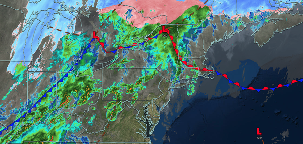
THIS EVENING
A prefrontal trough will produce waves of showers and thunderstorms. The strongest thunderstorms will be capable of heavy downpours, frequent lightning, hail, and wind gusts over 40 mph. Minor wind damage, urban flooding, power outages, and visibility below a mile will be a threat from these thunderstorms.
TONIGHT
A cold front will approach the region with scattered rain and snow showers. Winds will be from the southwest at 5 to 15 mph. Low temperatures will range from the lower to mid-30s over the interior and mid to upper 30s along the coast.
TOMORROW
A cold front will move through the region with
scattered rain and snow showers. Winds will veer to the northwest at 5 to 15 mph. High temperatures will range from the mid to upper 30s for higher elevations, lower to mid-40s over the rest of the interior, upper 40s to lower 50s in the Delaware River Valley, and lower to mid-50s along the coast.
TOMORROW NIGHT
High pressure
will build into the region with clearing skies. Winds will be from the northwest at 5 to 15 mph. Low temperatures will range from the mid to upper 20s.
FRIDAY
High pressure will produce scattered clouds. Winds will be from the south at 10 to 20 mph with gusts over 30 mph. High temperatures will range from the lower to
mid-40s over the interior and mid to upper 40s along the coast.
SATURDAY
A trough will produce scattered clouds and isolated showers. Winds will be from the west at 10 to 20 mph. Low temperatures will range from the upper 20s to the lower 30s over the interior and mid to upper 30s along the coast. High temperatures will
range from the lower to mid-40s over the interior and mid to upper 40s along the coast.
SUNDAY
A warm front will produce variable clouds, isolated showers, and windy conditions. Low temperatures will range from the mid to upper 20s over the interior and lower to mid-30s along the coast. High temperatures will range from the lower
to mid-40s over the interior, upper 40s to lower 50s in the New York City metropolitan area, and lower to mid-50s in the Philadelphia metropolitan area.
MONDAY
A cold front will produce periods of showers and an isolated thunderstorm. Low temperatures will range from the lower to mid-40s over the interior, mid to upper 40s in the
suburbs, and lower to mid-50s in urban areas. High temperatures will range from the mid to upper 50s over the interior and the New York City metropolitan area, and lower to mid-60s in the Philadelphia metropolitan area.
TUESDAY
High pressure will build into the region with clearing skies. A few flurries will be a threat for the
Poconos and Catskills. Low temperatures will range from the lower to mid-20s over the interior, upper 20s to lower 30s in the suburbs, and lower to mid-30s in urban areas. High temperatures will range from the upper 20s to lower 30s in higher elevations, mid to upper 30s over the interior, and lower to mid-40s along the coast.
WEDNESDAY
High pressure will produce scattered clouds. Low temperatures will range from the upper 10s to lower 20s over the interior and lower to mid-20s along the coast. High temperatures will range from the lower to mid-30s over the interior and mid to upper 30s along the coast.