UPDATED 03/15/26 4:49 PM
A warm front will bring waves of heavy rainfall late tonight through tomorrow morning. A cold front will then produce waves of showers and thunderstorms, a few of which will be severe, making for a stormy start to the week.
THIS EVENING
Overcast skies will continue through this evening with showers developing towards midnight. Winds will be from the east at 5 to 15 mph. Temperatures will slowly rise through the 40s.
TONIGHT
A
warm front will approach with rain, heavy at times, and embedded thunderstorms developing after midnight. Winds will be from the southeast at 5 to 15 mph with gusts up to 30 mph. Low temperatures will range from the mid to upper 40s over the interior, upper 40s to lower 50s in the suburbs, and lower to mid-50s in urban areas.
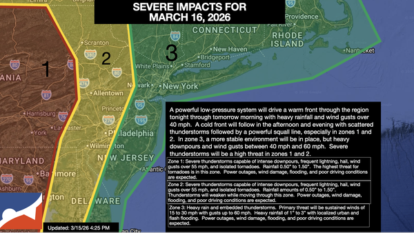
TOMORROW
An area of low pressure with a warm front in the morning, followed by a cold front in the afternoon with produce waves of rainfall and embedded strong and severe thunderstorms. The thunderstorms will be capable of heavy downpours, frequent lightning, wind gusts up to 60 mph, hail, and isolated tornadoes. Winds will be from the south at 15 to 30 mph with gusts over 40 mph. High temperatures will range from the mid to upper 50s on Long
Island, upper 50s to lower 60s over the interior and New York City metropolitan area, and mid to upper 60s in the Philadelphia metropolitan area.
TOMORROW NIGHT
The cold front will clear the region with heavy rain and thunderstorms ending around midnight, followed by rapidly clearing skies. Winds will veer to the west at 5 to 15
mph. Low temperatures will range from the mid to upper 20s over the interior and lower to mid-30s along the coast.
TUESDAY
High pressure will build into the region with clearing skies. Winds will be from the west at 10 to 20 mph with gusts over 30 mph. High temperatures will range from the upper 20s to lower 30s over the
interior, mid to upper 30s in the New York City metropolitan area, and upper 30s to lower 40s in the Philadelphia metropolitan area.
WEDNESDAY
High pressure will produce scattered clouds. Winds will be light and variable. Low temperatures will range from the lower to mid-20s. High temperatures will range from the upper 30s
to the lower 40s.
THURSDAY
High pressure will produce scattered clouds. Low temperatures will range from the upper 20s to the lower 30s. High temperatures will range from the mid to upper 40s over the interior, mid to upper 40s on Long Island, and upper 40s to lower 50s throughout the rest of the
region.
FRIDAY
A warm front will approach the region with increasing clouds throughout the day. Periods of showers can be expected in the evening for most of the region, and a wintry mix can be expected over the interior. High temperatures will range from the upper 30s to lower 40s over the interior, mid to upper 40s in the New
York City metropolitan area, and upper 40s to lower 50s in the Philadelphia metropolitan area.
SATURDAY
A cold front will produce variable clouds and widely scattered showers. Low temperatures will range from the lower to mid-40s. High temperatures will range from the mid to upper 50s on eastern Long Island, lower to mid-60s in
western Long Island, upper 60s to lower 70s in the New York City and Philadelphia metropolitan area, and mid to upper 60s over the interior.
SUNDAY
High pressure will produce scattered clouds. Low temperatures will be in the mid to upper 20s over the interior and lower to mid-30s along the coast. High temperatures will be in the
lower to mid-30s in higher elevations, upper 30s to lower 40s over the rest of the interior, and lower to mid-40s along the coast.